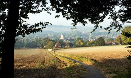
Oxford is under threat. In recent months, the council has been responding to widespread concerns that the city of “dreaming spires” was about to be swamped by a rash of tall new buildings. As a result, alongside English Heritage and other agencies, the council has devised policies that create a series of protected views, triangular sections that cut across the map in order to preserve the vertical skyline of the city.
A selection of city panoramas from particular points of historic or local interest have been protected, taking in not just individual historical buildings but also the topography, the city as a landscape of natural features, variegated heights and forms, combining into a pleasing image. As the interim report for the Oxford Views study says, this harmony is constantly in jeopardy, facing “the continuing challenges of building within the city to meet the demands of a modern society.”
What is the right shape for a city? This is a question that underpins the policy of protected views today. Since the 1960s, different city governments have looked at the preservation of views as a way of controlling the shape, in particular the vertical outline, of cities. How tall should a building be and where should it fit in? Are skyscrapers only for downtown? What kind of building – office, monument, apartment block – should be allowed to rise into the sky? What can it obscure and what must it not overshadow? Like with the green belt, devised in the 1930s to limit the outward expansion of the city in the face of railways and the car, today we face a crisis of verticality.
Protected views are a fluid combination of concerns relating to the transformation of the city. For some, cities are changing too fast and in the wrong places. They are losing their character and being replaced by an ubitquitous glass and steel architecture that offers no sense of location. Tall towers are replacing the human scale of the city’s heritage. We are destroying the role of topography, ignoring and overpowering that natural surrounding that gives the city a sense of place. Protected views are ways of managing change: restricting growth in some parts, ring-fencing and preserving the significant aspects. It prioritises the ocular encounter with the city. The metropolis must “look” right to be right.
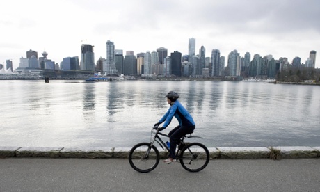
Vancouver was one of the first cities to organise its preservation policy in the late 1980s according to a series of “view corridors” that took in the balance between a rising downtown, the port and waterways and the North Shore mountains in the background.
At the same time, there was public concern about the “Manhattanisation” of the financial district of San Francisco that many people thought would damage the “city pattern”. This was developed into a general plan passed into law in 1995, including the preservation of “major views whenever it is feasible, with special attention to the characteristic views of open space and water that reflect the natural setting of the city and give a colourful and refreshing contrast to man’s development.”
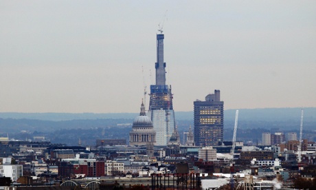
A similar commitment to preserving London’s heritage with the development of “sightlines” was included in the 2004 London plan, published by mayor Ken Livingstone, and based around the aspects and panorama that include historical sites such as St Paul’s Cathedral, the Tower of London and Westminster Palace.
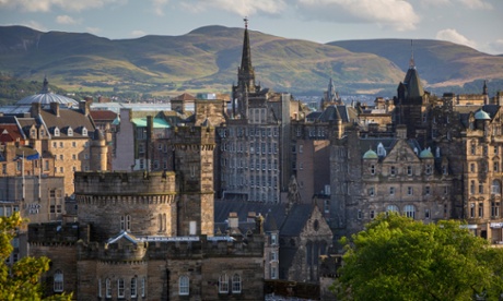
This makes a certain amount of sense at first impression. Who could disagree with the idea that the view from Parliament Hill towards the dome of St Paul’s is not one of the delights of London’s skyline? Or that the shape of the shoreline from the castle ground is a wonder to encounter, having made the steep climb up the Royal Mile in Edinburgh? But there are a number of assumptions about what the city is, and what it should be, that are often lost in the presentation.
For example, are protected views the best way to preserve the heritage of the city? The 2006 Street View study conducted by Edinburgh city council noted some places were “fundamental” to the city, and key views were “precious” and even “sacrosanct” in providing a “sense of the city”. Nine significant locations were then identified, with a series of views from multiple angles drawn on to the map and a calculation for the “sky space” around the sites in order to allow its view to remain unhindered. In addition, 22 landscape areas were highlighted for special consideration.
In the end, however, the map of the city is so criss-crossed with view cones that it makes development difficult. How can we be sure that this does not turn the city into a museum?
Such restrictions can be creative, encouraging planner and architect to think about their designs fitting into the grain of the place, in conversation with their surroundings rather than standing alone in the landscape. However, there are other strains that put pressure on the existing fabric of the city and raise questions about the efficacy of protected views.
A few weeks ago, I stood at the top of San Francisco’s Dolores Park, looking back across the city towards downtown. The city flows, undulating across the landscape, with clusters of three- and four-storey houses, offices and the odd church tower breaking the surface, until it crests with the rising heights of the warehouses and factory buildings – now converted into lofts and startup offices, such as the Twitter offices on Market St, in SoMa, the municipal buildings that huddle around the Civic Centre, and, in the background, the shining towers of the financial district. The buildings follow the curves of the hills and the valleys.
This landscape was the result of time and changing planning policies, as well as a contested idea of what the “city pattern” should be. The San Francisco general plan itself was created in horror at the rapid growth of the downtown, the mushrooming of alien towers in the financial district. But now the crisis is not of new office and retail spaces, but housing. As our cities grow, where do we fit everyone?
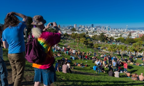
During my visit, the main topic of debate was gentrification: how young, educated workers – often earning huge amounts in jobs in nearby Silicon Valley – were moving into downtown neighbourhoods, displacing the local communities. You can see that the Mission neighbourhood has already changed from a predominantly Mexican one to artisan coffee shops, interior decorating parlours and bike workshops. The same is happening in every major city of the world.
Without building more housing, the city will squeeze out those who can least afford it: and the best way to build with the necessary kind of density in mind is upwards. In the face of this escalating demand for housing, the mayor Ed Lee, a former housing campaigner from Chinatown, proposed 30,000 new units by 2020. In other places, changing policy in height restrictions has become par for the course.
In 2010, Vancouver voted to raise the height of the city outside the view cones from 600ft to 700ft, and in every subsequent year has conducted height reviews to allow for taller buildings in exchange for investment in social projects. In the same year, Paris relaxed its maximum height to 590ft. In 2014, President Obama signed an amendment to Washington DC’s 1910 Height Act that allowed for the building of penthouses to existing tall buildings in the district.
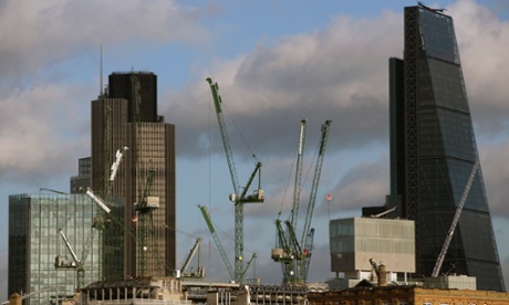
If the height of a building is itself a moving target, is the policy of protected views perhaps less useful than imagined? As the example of London proves, this policy has done very little to curb development, and has, perhaps, even made the rash of new luxury housing towers that have erupted across the city more blighted. In particular it has shown that the policy of protected views is as much to do with political machinations of mayors, planners and developers as it is a vision of what the city of the future should look like.
The city’s strategic view policy was first proposed in mayor Livingstone’s 2005 London plan, with a list of 26 views. Notably, this was the year after the completion of 30 St Mary’s Axe, the Gherkin, that heralded the vertical turn in London planning. The policy was intended to preserve some of the low level but historically significant aspects of the city; both places and scenes. Since then we have suffered an outbreak of towers that symbolise not just a rising up of the city, but a new strategy of investment and development that has very little interest in the past, instead turning the metropolis into a landbank.
Planning for the policy started long before the idea of a mayor of London was even mooted. A view management guide was first issued by the Major government in 1991, which hoped to define the nation as a place of warm beer and the village green. This was handed over to City Hall when it was invented in 2000. Livingstone saw the policy as a way of managing development rather than restricting it.
In his first review, he reduced the viewing cones from 440m to 210m, while rules governing the views along the Thames were relaxed. Tellingly, the document notes that the mayor and local planning officers should “normally refuse” all developments within the view cones, of course allowing a trap door out of the policy altogether. Mayor Johnson, while claiming to see London as a horizontal city, has found it useful, on occasion, to put his personal rubber stamp upon a project to see it go through.
This makes the whole policy a value judgement by those in positions of power. Take, for example, the identity of the London skyline itself that was questioned in 2011 by the chief planning officer of the City of London, Peter Rees. He pointed out: “London doesn’t have a skyline, it’s had a series of chance events which, apart from St Paul’s, isn’t very distinctive.” What better argument against the preservation of the city skyline than saying it never existed in the first place?
Thus, when we see development flourishing in places such as Vauxhall, Victoria and Southwark, we can no longer be sure that it abides either by the London View Management Framework [LVMF] or by some form of political expediency. It is also clear that, as these large schemes continue to rise, public consultation and involvement is becoming increasingly pushed away and ignored. For City Hall, Londoners are not necessarily the first customer that needs to be looked after.
The policy of protected views is clearly, more often than not, a short term political opportunity rather than a philosophy of urban planning. The truth is that a policy that appeared to find purchase in the 1980s and 1990s, driven by a fear of an empty downtown, no longer makes any sense. Instead, what the policy has done is to see the city from a distance, and, as a result, the people who actually live and work there appear very small; often invisible.
So Oxford should not believe that they will save the city of spires just by creating view cones that traverse the city. Rather, the city needs to develop a programme for growth that takes into account not just the architecture but also the people that live their everyday lives between these monuments.
Follow Guardian Cities on Twitter and Facebook and join the discussion
guardian.co.uk © Guardian News & Media Limited 2010
Published via the Guardian News Feed plugin for WordPress.